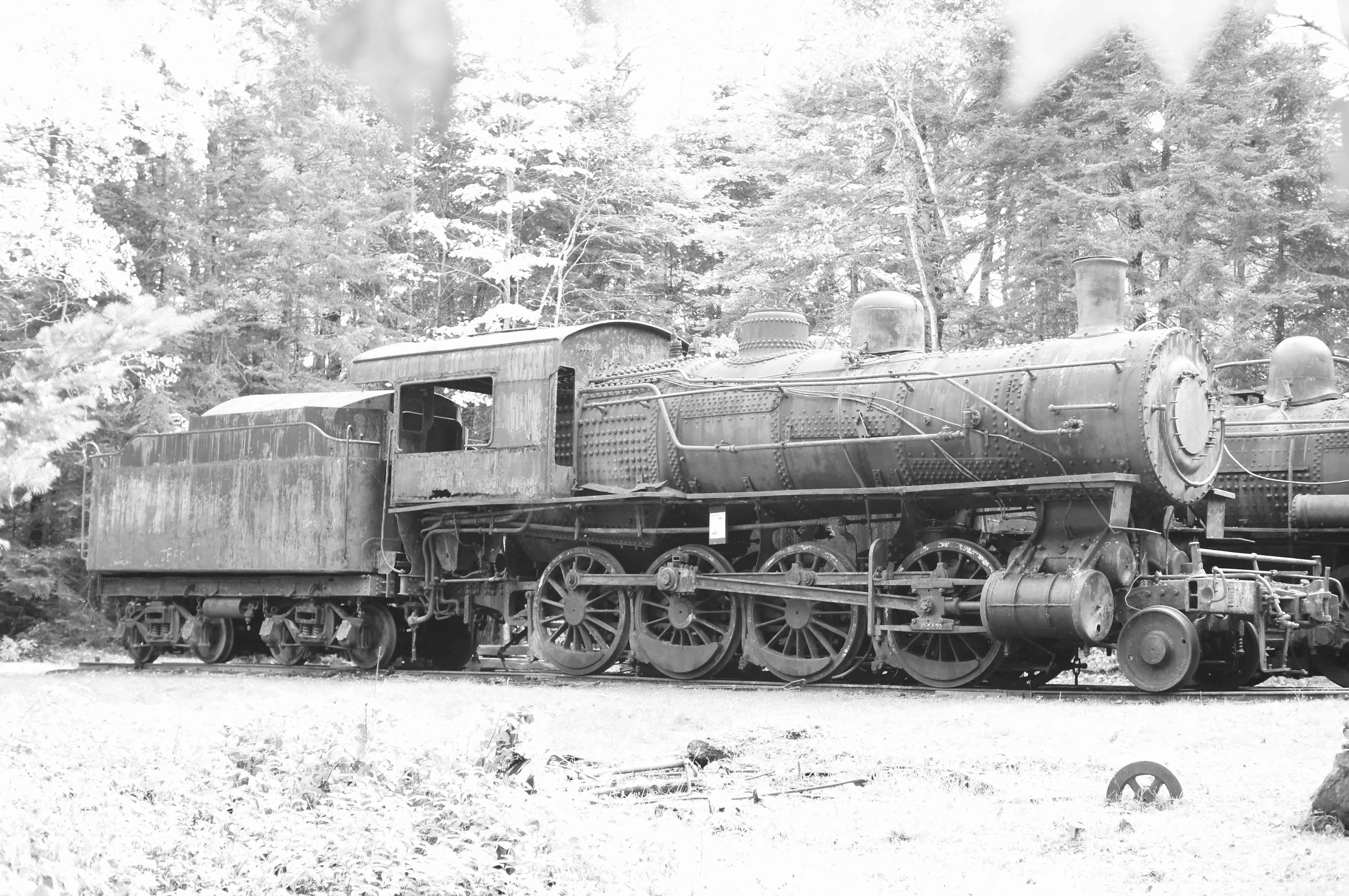
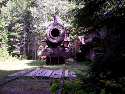
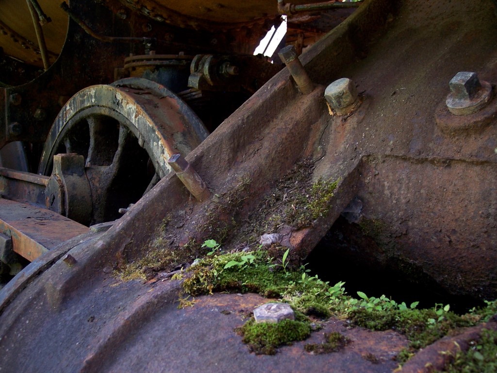
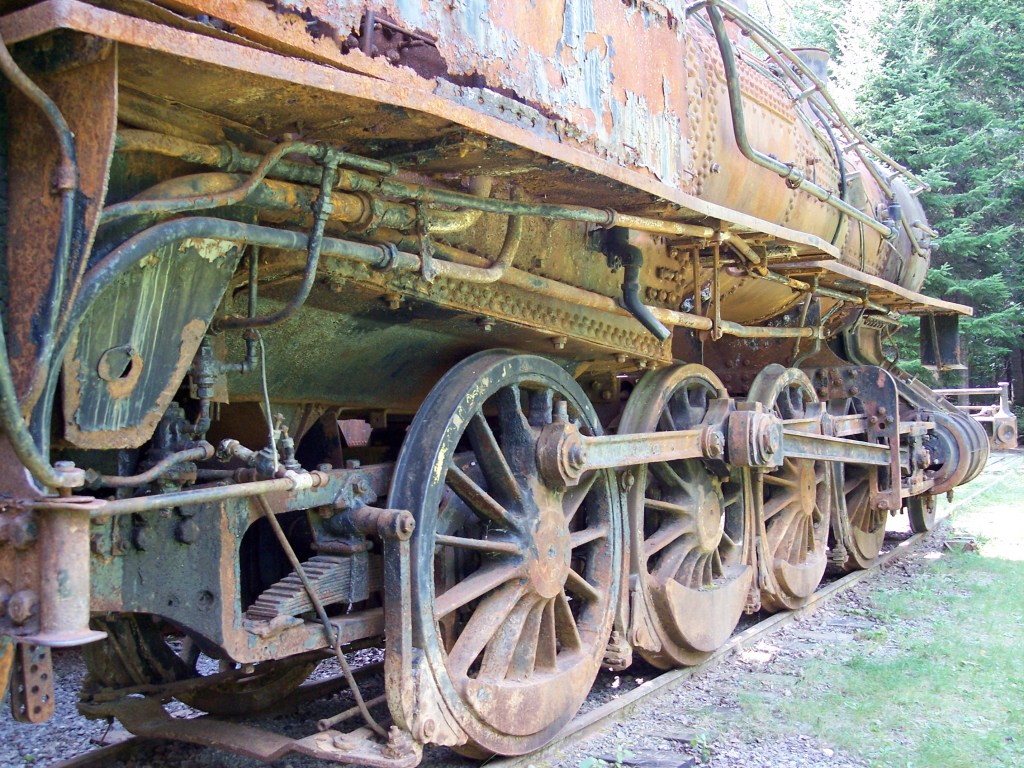
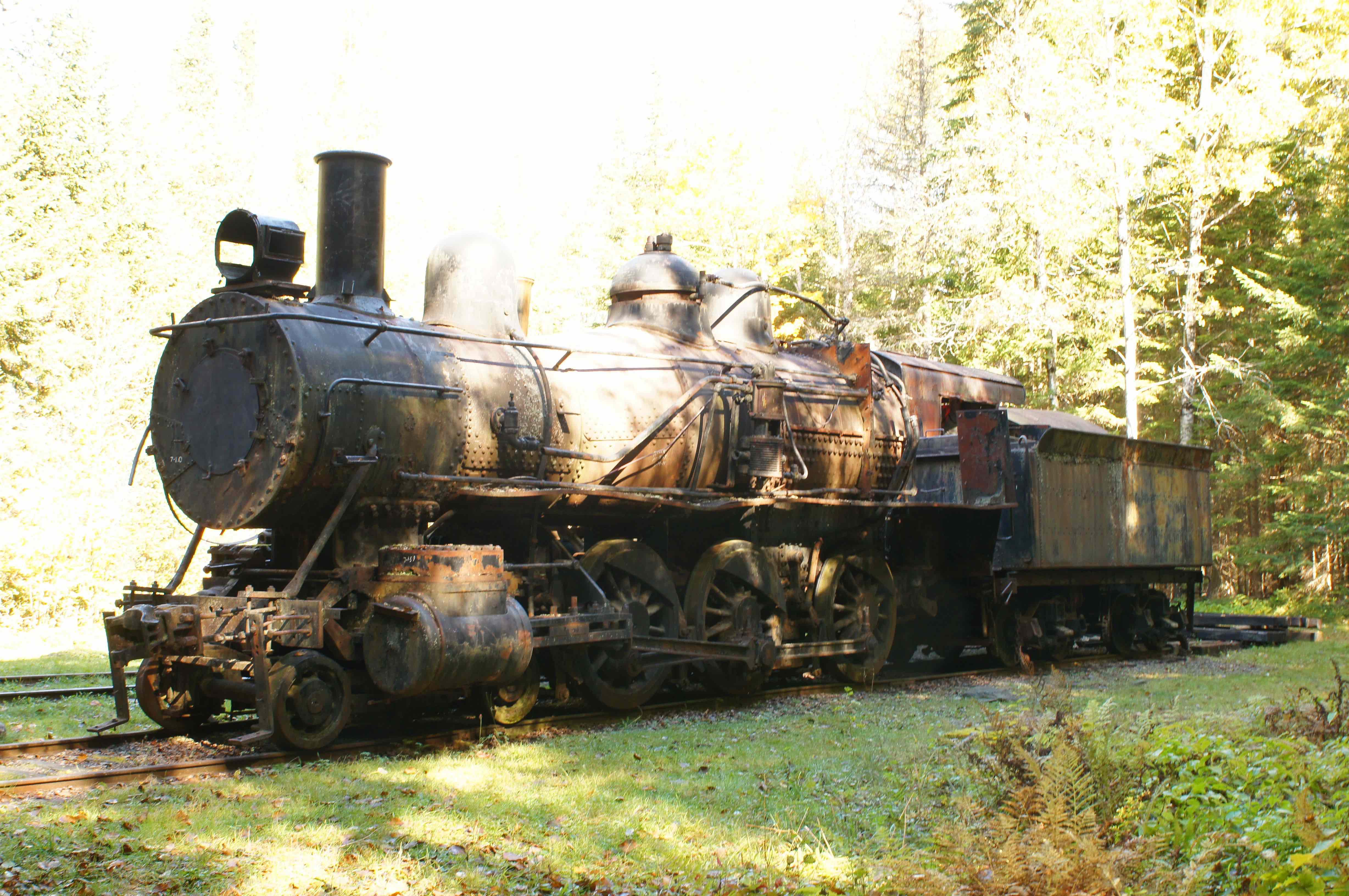
A pair of abandoned, standard-gauge steam locomotives of the Eagle Lake & West Branch Railroad stand side-by-side in a small clearing deep in the north woods of Maine. This is a guide to finding them. One of the engines has a 2-8-0 wheel arrangement and one is a 4-6-0. That’s eight driving wheels on one, six driving wheels on the other. The first digit in each wheel arrangement refers to the number of pilot wheels at the front of the locomotive, one on each side (or two). The zero in each arrangement means that there are no trailing wheels behind the tall driving wheels. Trailing wheels were used on more modern steam engines to help support the firebox-end of the boiler, normally surrounded by the cab. The middle number in 2-8-0 and 4-6-0 tells us that there are four tall driving wheels on each side of one locomotive and three on each side of the other.
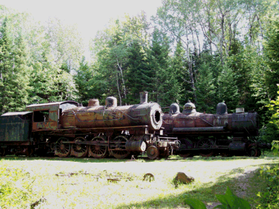
Railroad historian Dale Roberts has written that “the 2-8-0 is formerly New York Central’s Lake Shore & Michigan Southern #5780 (780) and was built by American Locomotive Company in its Brooks Works. The 4-6-0 was Indiana Harbor Belt (also owned by New York Central) #15 (and has also been numbered 109), also built by ALCO but in its Schenectady New York assembly plant.“
Regarding identification of remaining steam locomotives in the U.S., Dale adds this resource: http://steamlocomotive.com/survivors/
Regarding the Eagle Lake & West Branch Railroad itself, see this site: http://www.eaglelakeandwestbranchrailroad.info/ — and anyone is very lucky who can find a copy of the book, Eagle Lake and West Branch Railroad – Meeting the Challenge of Logging in the North Maine Woods by Richard N. Symonds, Jr. The book is out of print and much in demand.
Finding the Locomotives
To get there by way of the Golden Road you may find the coordinates, below, useful.

(There are directions further down for getting there by way of Chamberlain Lake.) The map positions listed at the bottom of this description are taken from my old handheld Magellan GPS, which I use mainly to mark significant spots, rather than to navigate. All coordinates are in the form degrees – minutes – seconds north latitude by degrees – minutes – seconds west longitude. You can recalculate all coordinates to decimal equivalents if you wish.
You can’t depend on a GPS for navigation by roads when you’re in the north Maine woods, because there are no addresses or landmarks like major highway intersections, and many of the roads you will be traveling are not marked on USGS maps or on the Maine Atlas and Gazetteer. It’s a wilderness owned and managed by numerous private landowners, who collectively permit access under the organization called North Maine Woods, also managed by the Maine Forest Service and Inland Fisheries and Wildlife. It is a wilderness without manmade landmarks, criss-crossed by private dirt roads, and the roads that are labeled on Google maps are often known differently by the locals, if you can find any locals. Obvious natural features in the woods, such as streams (some with bridges), lakes, gravel pits, and hilltops, are ignored by an automotive navigation GPS.
You can use a GPS, however, to zero in on a given set of coordinates. You need a copy of the Maine Atlas and Gazetteer or the appropriate USGS maps up here. I’ve never plotted exact distances or driving times, so the distances below are taken from guesses and memory and eyeballing the Gazetteer. You’re looking at two, or up to three hours of driving time from Millinocket, but that’s a wild guess too, and depends on how much time you spend walking around at various attractions along the way.
There are only two reasonable ways to take this trip from May to September. From mid-September through November, not only is it hunting season for moose and deer, but the weather makes hiking and boating especially hazardous, especially if someone gets soaked, which can happen for more reasons than you can imagine. In the winter there are reliable snowmobile routes — a third way of getting there for those who like winter adventures.

In the fairer seasons it’s best to take two days (departing from Millinocket), and go prepared for one night of primitive camping. I recommend hiking in to see the locomotives on the first day and camping overnight near Umbazooksus Dam. You can also do it in one day, leaving early from Millinocket (or Millinocket Lake) and returning to your starting point that evening, however you will not have time to explore the other end of the rail line at Umbazooksus or the sites in between.
Directions for GETTING THERE
From Millinocket follow signs for Baxter State Park. There is a built-up area on the way to the park, about seven miles from Millinocket (North Woods Trading Post, Big Moose Inn, campground, boat launch, righthand turnoff for NEOC) all jammed between Millinocket Lake and Ambajejus Lake. Where two roads run parallel at this built-up area, cross over to the road on the left, the Golden Road, and continue on this road. Follow the Golden Road for twenty-some miles, and when you reach the Chewonki camps and campground (formerly Big Eddy campground) on the right, begin watching for a right turn onto the Telos Road, a few hundred yards ahead. (There is no sign that says Telos Road.)
Take the right onto the Telos Road, which immediately crosses a short bridge over the West Branch of the Penobscot River. (An interesting diversion lies just after the bridge, a parking area with outhouse and short hike to the river’s edge.) Soon after the bridge, the pavement ends, and from there onward you’re on dirt roads, but for the first half of the remaining distance these are well-maintained for two-way traffic and log trucks; I sometimes reach 50mph on the longer stretches, although, at that speed, sudden bone-jarring washouts and holes appear without warning. Enjoy the ride and watch for moose, especially in a large sand pit about eight miles up the Telos Road, on the left. Seven miles or so after the sand pit you will come to a checkpoint for North Maine Woods, with a cluster of little buildings on the left. Stop and go inside and register your intentions. The last I recall, the day-use fee was $10 per person over 15 and under 70. If you intend to camp overnight, you can get information about available campsites and fees.
After the checkpoint, it’a about ten miles straight north to a ‘T’ in the road. If you go right at the ‘T’ you will come immediately to Chamberlain Bridge, on the channel between the extreme south end of Chamberlain Lake/Telos Lake to the north of the bridge and Round Pond to the south. There is a boat launch at the bridge, in case you intend to run the 15 miles or so up the lake. If you plan on hiking in to the locomotives, which I recommend, then at the ‘T’ go LEFT. (Or go right, check out the bridge, which has a north view of Katahdin, and then go back as if you had taken a left.) There are opportunities to take a wrong turn anywhere along the road system, but you’ll realize it shortly if you do.
Go six to seven miles west-southwest and take the swing to the right onto what the map calls Grande Marche Road. If you miss this turn and continue straight here instead, it’s about a mile to Umbazooksus Lake. This was the southern terminus of the Eagle Lake & West Branch Railroad, and there are a few relics here. Walk across the short dam at Umbazooksus and you may find railcar wheel sets in the gravel along the lake’s west shore. It takes some searching. The rail line ran up the east shore of the lake, and you can find the undulations in the swampy ground where the cross ties used to lie, on the very southern tip of the lake next to the road.
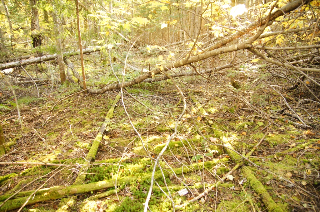
It’s not feasible, on a casual visit, to follow the old rail bed, for reasons that will become apparent if you try. (Swamps, dense growth, trunks of dead trees across the way.) But there are some easily-accessed stretches where you can follow it for a few yards or farther, as much as you can tolerate the difficulty. I once intended to hike the 13-mile length of the rail line, but that proved completely insane without bringing heavy equipment, or at least a chain saw and lots of gas.
Once you’re on Grande Marche Road, watch for the spot where the tracks would have crossed the road, about 3-4 miles up (see Crossing under ‘Coordinates’ below). The logging road is newer than the railroad, so it was not a crossing when the railroad was running. At what is now the crossing, Great Northern Paper, which used to own these woods and roads, apparently tore up the rails for some distance back from the newly-laid logging road and even piled some rails next to the road, although I expect that some day I will go by there and the pile of rails will be gone. But, if you hike into the woods at the crossing, especially to the east, you will come to the original rails on the original unballasted roadbed, such as it was. The rails are almost hidden for good in the grasp of the wet ground which is swallowing it all up. To the west of the crossing you can, with effort, reach the north shore of Umbazooksus Lake.
From the crossing, continue about another 10 miles on Grande Marche Road, keeping to the right when presented with an unclear choice, until you cross a short bridge over Allagash Stream. Within a mile or so, on the right, there will be two lesser roads. Skip the first, less-passable one and take the second, which is in better condition (First Right under ‘Coordinates’). Note, however, that since 2017 there has been work under way to open a new way in to the locomotives using the first of these two lesser roads.
Assuming you take the second “lesser road” on the right after the bridge, proceed a mile or maybe more to the last turnoff, which turns south,(Second Right under ‘Coordinates’). There are false turns here, so use the GPS coordinates provided to guide you. At this last turnoff, as you look down the final road, you’re looking downhill (not a steep hill) and, depending on the encroaching undergrowth, you can see quite a long distance down this road.
At the point I call “Park” under ‘Coordinates’ there are sometimes large boulders placed across the final road, and sometimes they’re not there. If they’re not there, go as far as your vehicle will safely take you on this southeasterly road and then park without obstructing the way. (Someone may have parked farther in than you’ve gone, so you need to allow them space to get by.) It’s now a hike to the southeast of about two miles to reach the locomotives, depending where you park.
Regardless where you park, you will still walk a distance on this southeasterly remnant of a road until you find the trail. It’s not marked well, but easy enough to guess at when you see an excess of marking tape on the scrub brush on the left. (Two spots are marked On Path N and On Path S under ‘Coordinates‘).
The path from this last road to the clearing which holds the locomotive is not a marked trail. If you’re used to following faint trails through the woods, you’ll make it, and just trust your coordinates anyway. What’s more, if you stay on a southeasterly tack you will absolutely come to the cable tramway and the wide trail that runs alongside it, because it spans the entire distance between the two lakes. From wherever you reach the tramway you can go left to the locomotives and Eagle Lake or right to the tramway equipment and Chamberlain Lake. It’s all flat trail terrain with no elevations to deal with but plenty of wet ground. The trail I normally take, provided I always find it and stay on it, actually runs down a stream bed for some dozens of yards. Waterproof hiking boots that come over your ankles are useful here.
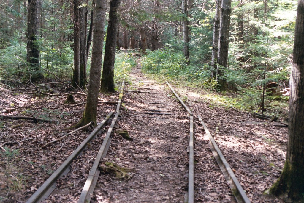
If you stay near the Eagle Lake side of the isthmus between the two lakes, as I do, then as you draw near to the clearing where the locomotives sit, you will begin to see relics in the woods, and eventually you’ll find yourself walking right between the rails that the trains once ran on. The rails are sinking into the ground and there are mature trees growing up between them. The locomotives are near the shore of Eagle Lake, along with much other equipment (Tramway under ‘Coordinates’ below).
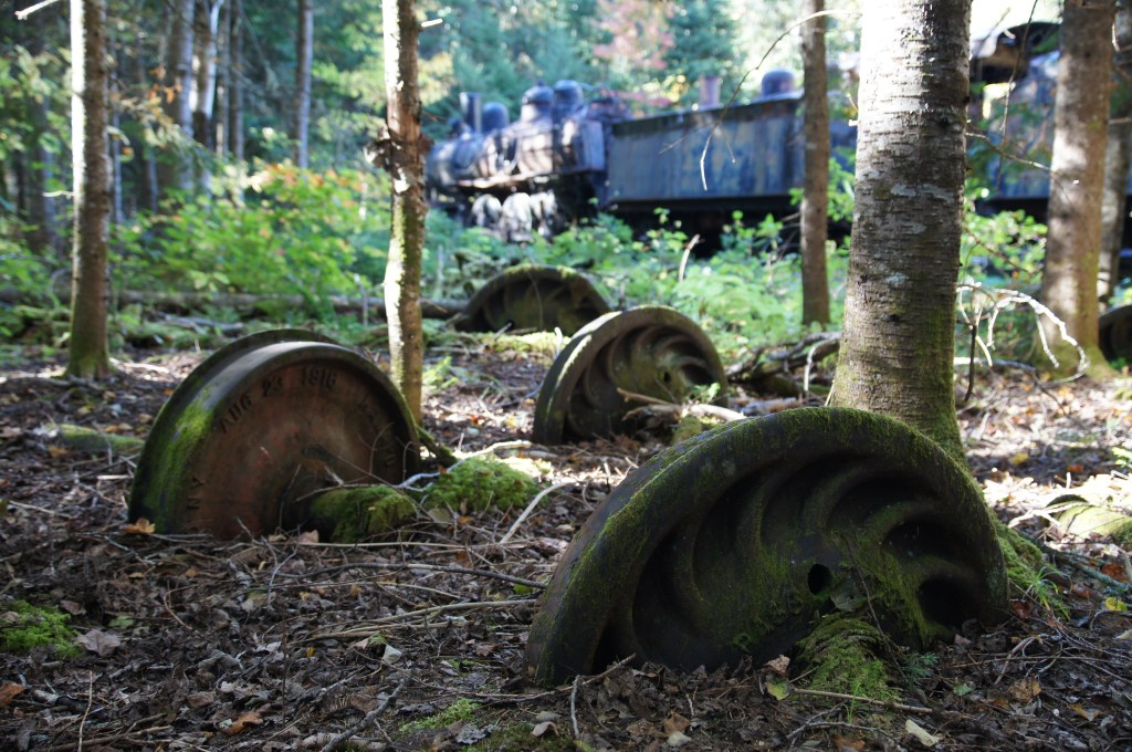
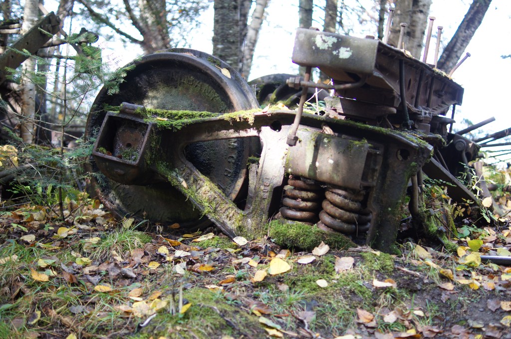
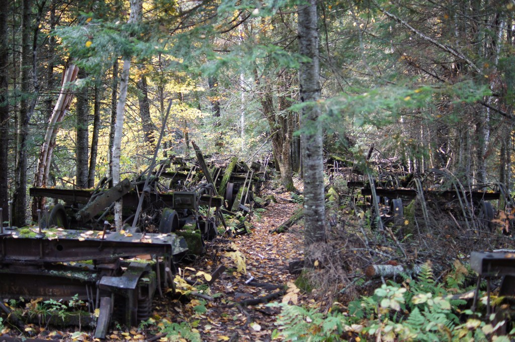
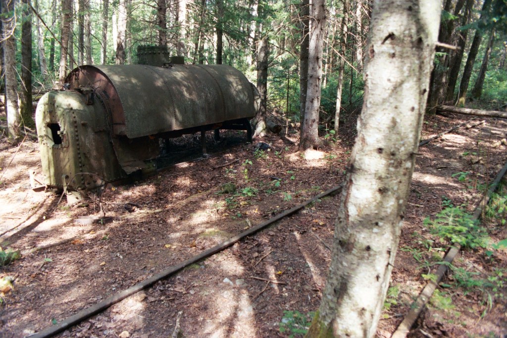
Just 25 yards east of the locomotives, almost on the shore of Eagle Lake, you will find what was once a small rail-yard populated with the remnants of log-hauling railcars and other gear. A few yards farther is a channel that was dug from Eagle Lake to the site where a large structure once stood, now gone, where the logs were pulled from Eagle Lake to be loaded onto the tramway. Among the other relics here are a large bronze boat propeller — (Nope! That had been hauled away last time I was there!) — and the crankshaft from an internal-combustion engine — look on the north side of the dug channel. (There are also a few fossil brachiopods within the rocks strewn on the beach.) A bunch of other relics are scattered in the trees behind the locomotive tenders.
Some History
The tramway came into existence in the 1920s before the EL&WB Railroad was built. Eagle Lake and the waters to the east and north of the isthmus flow northward and eastward, deep into Aroostook County. Chamberlain Lake and the waters to the west and south flow into the West Branch watershed — the West Branch of the Penobscot River, which ultimately flows directly through Millinocket. In fact, the river was diverted, around 1899-1901, to flow directly through the Great Northern Paper Company mill at Millinocket.
In order to get the raw timber, that was cut around Eagle Lake and to the east of the lake, over to the West Branch watershed, the company needed a means of transferring the logs from one watershed to the other, and this narrow spit of land between the two lakes was the logical place to do it.
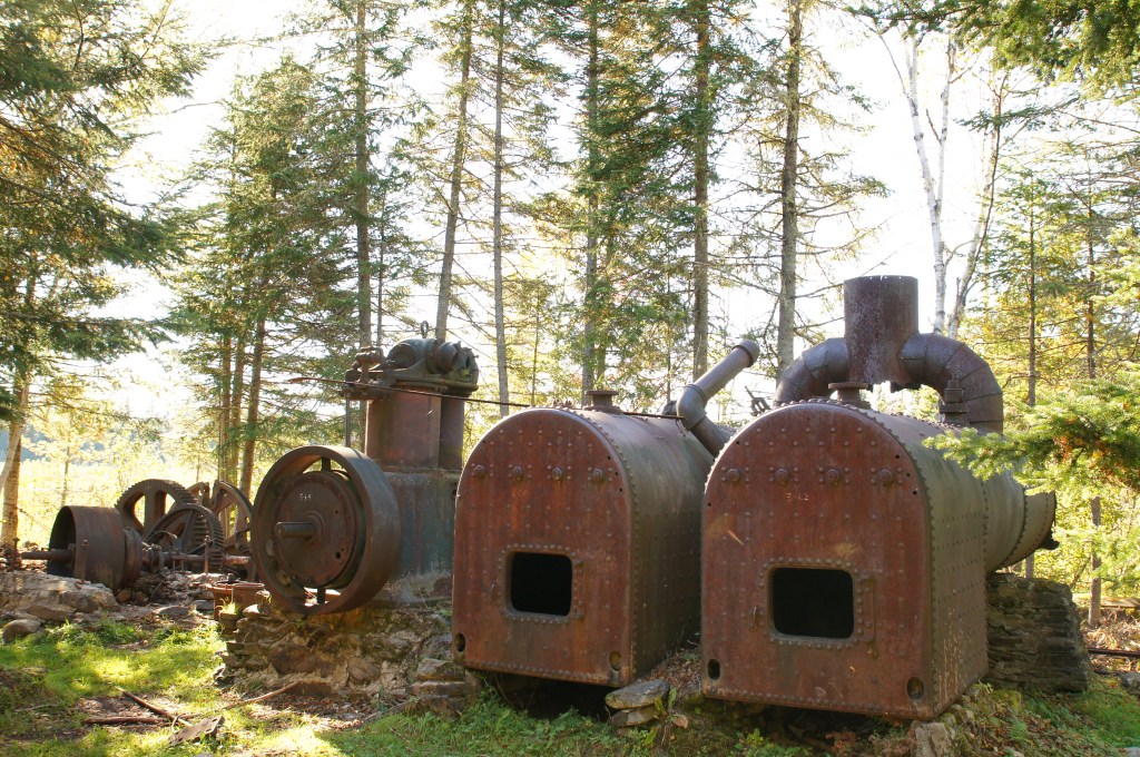
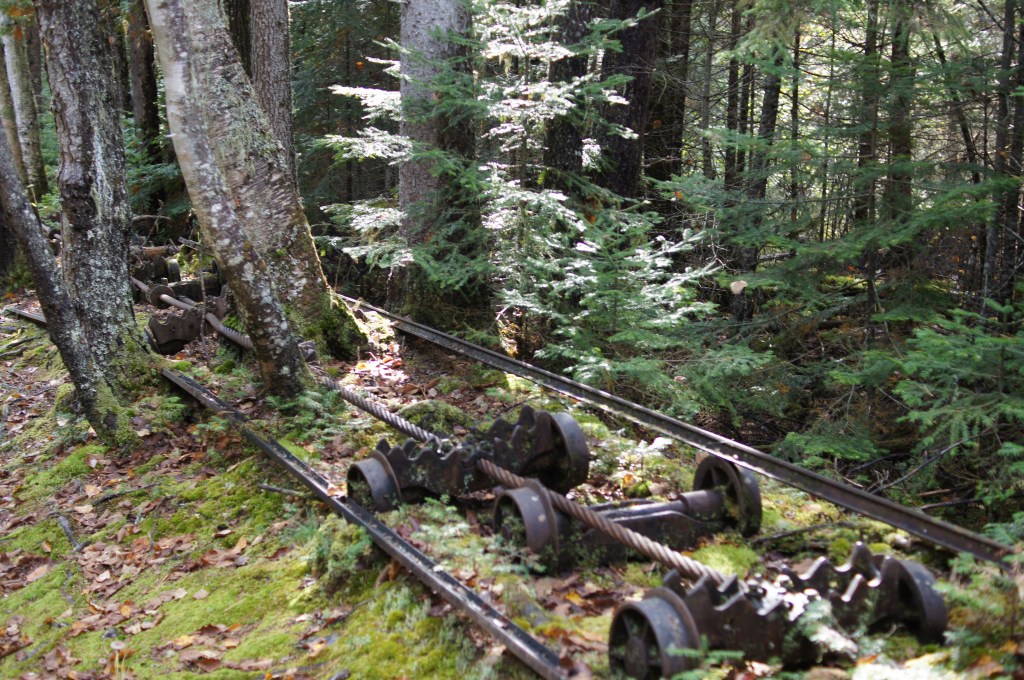
The tramway consists of a 6000-foot loop of steel cable (still there) which runs from Eagle Lake to Chamberlain Lake, a span of 3000 feet, which was towed by a pair of stationary boilers at the Chamberlain Lake. Small sets of wheels rode a pair of miniature rails (tiny compared to a standard-gauge railroad) and long logs were dragged from the shore of one lake to the shore of the other on these little wheels.
The tramway turned out to be inefficient and inadequate to the task of transporting the quantity of timber that was expected of it. So they abandoned it for a standard-gauge rail line, starting at the same point on Eagle Lake where the tramway began. There is a pleasant highway of a hiking trail alongside the remains of the tramway, which is the word often but misleadingly used to refer to the whole place where the locomotives and all the relics now lie. So it is just over a half-mile hike to reach the other end of the tramway at Chamberlain Lake, well worth the time to see the equipment (and restoration under way) there.
There are some historical placards on the locomotives and among the relics explaining that this whole operation was built in the 1920s (and abandoned in the 1930s) so that logs which had been cut to the east of Eagle Lake could be floated across that lake to the dug channel next to the locomotives. Once the railroad made the tramway obsolete the railroad delivered them by log car the 13 miles to Umbazooksus Lake. At Umbazooksus they were dropped into Umbazooksus stream, which is really the northern tip of Chesuncook Lake. Ripogenus Lake is the southern half of the same body of water. Logs could then drop alongside Ripogenus Dam into the beginning of the West Branch of the Penobscot River. Log drives like this, though, ceased in the early 1970s and that’s when the Golden Road was extended to the border with Canada to the west and into the Allagash region to the north.
Once you have reached the locomotives and are exploring the tramway and equipment, be sure to leave yourself enough time to hike out to your vehicle before dark.
Coordinates
Umbazooksus south shore
46º 08’ 52”N
-69º 20’ 49”W
Crossing (where the Grande Marche Road crosses the rail bed)
46º 11’ 54”N (46.198333)
-69º 22’ 36”W (-69.366667)
First Right
46º 19’ 54”N
-69º 25’ 29”W
Second Right
46º 20’ 41”N
-69º 24’ 37”W
Park
46º 20’ 29”N
-69º 24’ 21”W
On Path N
46º 19’ 48”N
-69º 23’ 29”W
On Path S
46º 19’ 40”N
-69º 23’ 27”W
Tramway (locomotives)
46º 19’ 25”N
-69º 22’ 31”W
To get there by way of Chamberlain Lake
First, look up the rules at the state of Maine’s web site on Park Rules, because you can use a motor up to 10 h.p. on Chamberlain Lake, but only on a craft defined as a canoe. Mine is a 21-foot Scott canoe, square-stern, powered by a 6 h.p. Johnson. Second, be equipped for an unexpected overnight stay. I have gone up Chamberlain Lake when it was glassy calm in the morning and there were whitecaps on two-foot breakers 20-feet apart by early afternoon. Third, there are hazards on the western shore of the lake, which is the lee shore in a normal gale, such as submerged rocks, so when the wind is up in the afternoon, the hazards almost force you to ride the rough seas out in the open instead of hugging the shore the way you’d like to.
You launch at Chamberlain Bridge, (go RIGHT at the ‘T’ mentioned above), then park your truck and trailer a short distance back the way you came, beyond the ranger station. You head north up a mile-long thoroughfare, which resembles being on a wide river. There are ten or so primitive campsites spaced along the west shore of the lake, and a couple on the east shore as well. The northernmost campsite on the west shore is called Crow’s Nest, if I remember correctly. I’ve used this one. It is near the pilings which are remnants of the low trestle that carried the railroad over the Allagash Stream inlet, and on the rise above Crow’s Nest, fifty yards up from the rocky beach, lies the roadbed to the old railroad. The rails are pulled up here, but the undulations in the earth tell you where the cross-ties used to lie. There are relics, and you can hike a fair distance in either direction (back toward the trestle, for instance).
To get to the tramway by way of Chamberlain Lake, you head into a swampy cove, a half mile across at its opening, located on the northeast end of the lake. (Follow the eastern shore into this grassy swampy cove until you come to a barely-discernible landing, which you can guess at because there is a bright clearing on the shore to aim for.) When you come by lake, you will be at the Chamberlain end of the tramway conveyor. There is a pair of standing boilers here, similar to steam locomotive boilers but stationary. A lot of other equipment is located in this clearing, and a team of volunteers has begun to reconstruct the tramway mechanism on this site. From here you would hike the 3000-foot distance to the Eagle Lake on the highway of a trail that I mentioned earlier, to get to the clearing with the locomotives.
I cannot responsibly publish these directions without some serious warnings: You MUST take proper equipment with you, and this can be much more than you suspect. You MUST carry certain extra equipment in your vehicle or boat, such as spare socks, spare drinking water, and so on. (Life preservers in a canoe, and if it’s over a certain length and powered, then also lights, horn, flares, and whatever else is currently required by boating law.) You MUST carry certain items in a bag or backpack as you hike. These would include a compass (make sure you can find the four cardinal points if nothing else), two ways to start a fire, a reliable full-tang fixed-blade knife, a whistle, a map (even a hand-drawn map) of where you’re going, GPS if you’re using one, and something to eat with protein in it to sustain you for a few hours. I urge that your backpack also include a rain parka, a “space” blanket, spare socks, a 24-hour supply of your daily medicine, and a spare layer such as a jacket, which can be stuffed into the pack or tied around your waist when it’s too hot to wear it.
Why all this stuff? Imagine breaking your ankle and waiting six hours to be carried to a waiting vehicle for the two-hour ride back to Millinocket. Assuming nothing goes wrong, you will also need to pack a meal and snacks for each person on the trip, as well as water to drink. Camera, binoculars, toilet paper. I carry a small-caliber sidearm to use for signaling and to discourage intrusive critters if I end up stuck in one spot too long, (not to kill an animal unless for safety or unless I need the food, but to frighten an unwelcome pest). You MUST be equipped to unexpectedly stay overnight anywhere in the woods. You MUST be prepared for NO CELL PHONE SERVICE six miles after leaving Millinocket. The list could go on and on, but please give this serious thought before striking out as if going to a museum in a city. Automobiles can take us to places where we would never be complacent if we had to get there by foot or horseback. And if the automobile fails, or if someone becomes lost or injured, that’s when it suddenly becomes serious.
You could, of course, hire a Guide, who would look out for all of the above concerns for you.
Final Thoughts
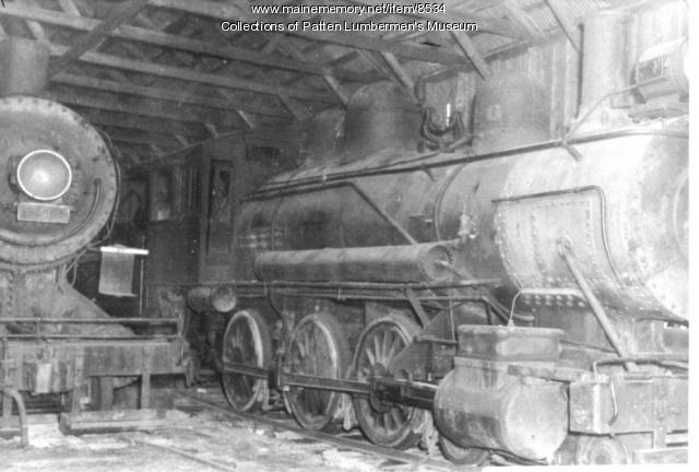
Let me add a few final words about the engines themselves. One is a 2-8-0, the other a 4-6-0, both apparently coal-burners. The cab on the 4-6-0 is missing. (The shed that had been built over them at one time burned in later years.) The other locomotive is intact, more or less.
There has been a little cosmetic work done on them since 2005, by whom I’m not sure, and frankly it’s hopeless. I do believe, though, that there will be recognizable remnants of them there for the next 500 years or so. Perhaps at some future date I will publish an article summarizing what I know about the locomotives and the railroad itself. I have tried to obtain a copy of Eagle Lake and West Branch Railroad by Richard N. Symonds, Jr., and have even contacted the author, but the book is out of print and he knows of not one copy available.
Here are a couple of web sites with more information, which you may be interested in:
Maine Historical Society’s Maine Memory Network web site on the Eagle Lake & West Branch Railroad
State of Maine Parks History on the Allagash Tramway
I welcome comments and updates to this set of directions.
